Will It Snow on Christmas?
Will it snow on Christmas this year? History gives your city a number — from a guaranteed white Christmas in Fairbanks to a 0% shot in Miami. Here are the official NOAA odds for where you live, and the December dates when this year's real forecast takes over from the record books.
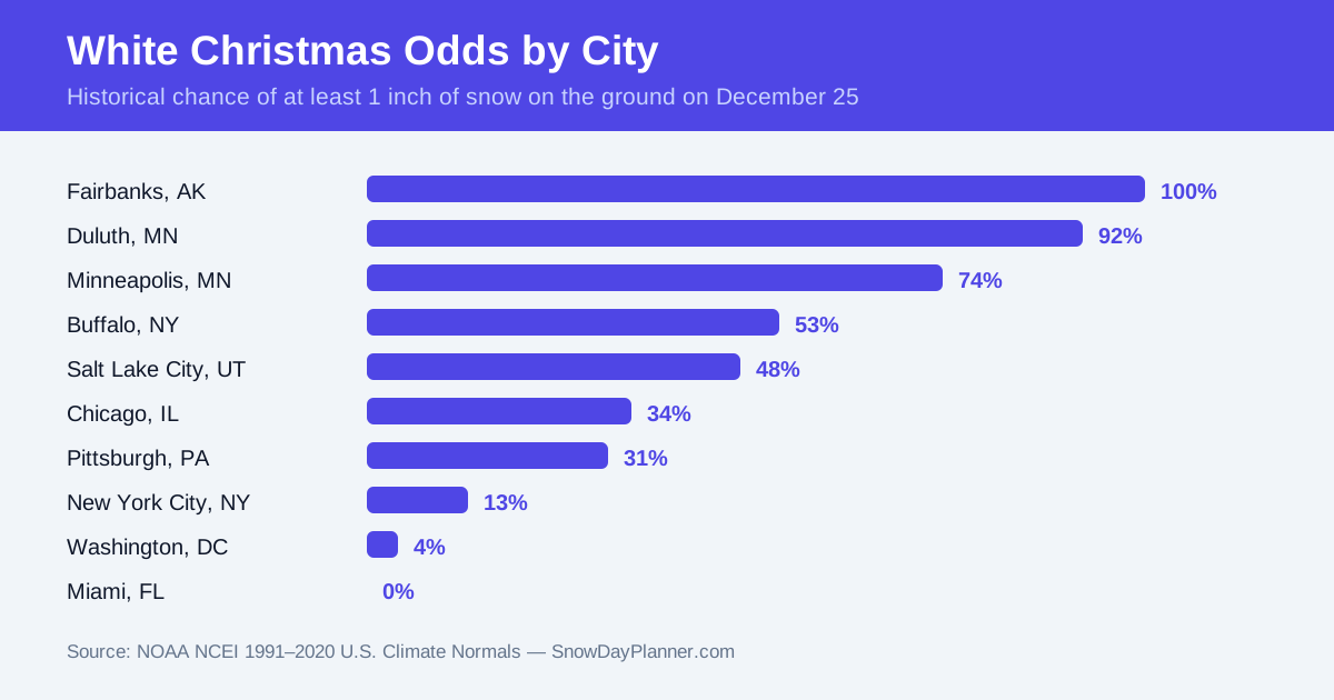
The short answer to “will it snow on Christmas” is that it depends almost entirely on where you live — and the climate record can prove it. In Minneapolis, snow has been on the ground on 73.6% of Christmases in NOAA's latest 30-year record. In Chicago the figure is 33.5%, in New York City 13.2%, and in Miami it is 0%. Those historical odds are the honest answer for most of the season. The forecast only earns the right to overrule them in the final week, when Christmas Day enters the reliable forecast window around December 18 — and from then on, the live calculator below is the number to watch.
Run your ZIP code in the calculator now for the current picture, then make it a daily habit from December 18: that is when the tool's hourly forecast starts covering Christmas Day itself, and when a genuine storm signal — or a genuine all-clear — first means something. Until that week, treat any Christmas snow map you see shared online as entertainment. The odds on this page are what history actually says.
What counts as a white Christmas?
NOAA's definition is precise: a white Christmas means at least 1 inch of snow on the ground on December 25. It is a measurement of snow depth, not of snow falling. A storm on December 22 that leaves 3 inches behind delivers a white Christmas even if the 25th dawns sunny and calm — while flurries on Christmas Day that melt on contact do not count at all. Every odds figure on this page follows that definition, drawn from NOAA's National Centers for Environmental Information (NCEI) 1991–2020 U.S. Climate Normals: for each weather station, the percentage of the 30 Christmases from 1991 to 2020 that had at least an inch of snow on the ground. NOAA's Climate.gov interactive white Christmas map plots the same data station by station.
Will it snow on Christmas in your region? The historical odds
The national pattern is a steep slope from the northern border to the Gulf. Snowpack that arrives in November and simply stays — protected by weeks of sub-freezing air — makes a white Christmas routine across the far north, while the southern third of the country needs a rare, perfectly timed storm. Here are the odds by region, from the NOAA normals:
| Region | Representative cities | Odds of a white Christmas |
|---|---|---|
| Alaska | Fairbanks · Anchorage | 100% · 93.7% |
| Upper Midwest & Lake Superior snow belt | International Falls · Duluth · Marquette | 93.3% · 92.2% · 82.1% |
| Northern New England | Caribou · Concord · Burlington | 87.2% · 62.6% · 62.3% |
| Northern Plains | Fargo · Bismarck · Sioux Falls | 77.6% · 71.3% · 58.7% |
| Great Lakes cities | Buffalo · Grand Rapids · Rochester | 52.7% · 53.4% · 51.5% |
| Mountain West | Flagstaff · Salt Lake City · Denver | 60.0% · 47.9% · 34.0% |
| Midwest cities | Minneapolis · Milwaukee · Chicago | 73.6% · 42.9% · 33.5% |
| Northeast & Mid-Atlantic cities | Albany · Pittsburgh · New York City · Washington, DC | 41.6% · 30.6% · 13.2% · 4.4% |
| Pacific coast & the South | Seattle · Atlanta · Dallas · Miami | 3.7% · 1.4% · 0.5% · 0% |
Where a white Christmas is almost guaranteed
One city in NOAA's data sits at a perfect score: Fairbanks, Alaska, at 100% — every Christmas from 1991 to 2020 had at least an inch of snow on the ground. Anchorage follows at 93.7%. In the Lower 48, the near-guarantees cluster where you would expect: International Falls, Minnesota (93.3%) and Duluth (92.2%) on the Canadian border, Caribou, Maine (87.2%) and Marquette, Michigan (82.1%) in the northern woods and lake-effect belts. The largest city with better-than-even odds is Minneapolis, at 73.6% — which is why our Minnesota snow day calculator and Michigan snow day calculator stay busy all winter. What these places share is not bigger storms but earlier ones: their snowpack is usually established by late November, and December cold simply preserves it. Their white Christmas question is rarely about Christmas week at all.
The coin-flip belt: where one storm decides it
Between roughly 30% and 60% lies the belt where Christmas is a yearly drama: Buffalo (52.7%), Rochester, New York (51.5%), Spokane (48.0%), Salt Lake City (47.9%), Erie, Pennsylvania (45.0%), Milwaukee (42.9%), Cleveland (39.7%), Detroit (34.7%), Denver (34.0%), Chicago (33.5%) and Pittsburgh (30.6%). In these cities there is no reliable early snowpack to coast on — a white Christmas usually needs a storm inside the December 20–24 window, close enough to the day that the snow has no time to melt, crust over or be rained away. That makes this belt the most forecast-sensitive in the country, and the place where checking today's snow day status and tomorrow's snow day chances during Christmas week genuinely changes plans — travel days, guest arrivals and the drive home all hinge on the same storm.
Where snow on Christmas is a long shot
South of the coin-flip belt, the odds fall off a cliff. New York City's Central Park station records 13.2% — about one Christmas in eight — and Philadelphia 9.3%, Baltimore 7.1% and Washington, DC just 4.4%. Seattle (3.7%) and Portland, Oregon (3.5%) are nearly as unlikely despite their northern latitude, because Pacific air keeps their Decembers wet rather than white. Across the South the numbers approach zero: Atlanta 1.4%, Dallas 0.5%, and Houston, Miami, New Orleans and Tucson all at 0% — not one white Christmas in the entire 30-year record. A long shot is not an impossibility, though: the 13.2% in New York still delivers a storybook Christmas roughly once a decade, and snow falling on the day is everywhere more common than snow on the ground — the official statistic is simply the stricter one.
Are white Christmases getting rarer?
In most of the country, yes — measurably. NOAA refreshes its climate normals every ten years, and when the 1991–2020 normals replaced the 1981–2010 set, the relatively warm 2010s rotated in and the snowier 1980s rotated out. A city-by-city comparison of NOAA's two data sets found the odds of snow on the ground on December 25 fell in 58 of 77 major cities. Spokane dropped from 56.9% to 48.0%, Salt Lake City from 52.5% to 47.9% and Erie from 50.3% to 45.0% — three cities that used to be better than a coin flip and no longer are. Chicago slid from 37.7% to 33.5% and Denver from 40.4% to 34.0%. The exceptions are worth noting: Anchorage rose 3.6 points to 93.7%, and New York City and Philadelphia both ticked up slightly. The trend is a slope, not a cliff — but if your childhood Christmases felt whiter than today's, the data says you are probably remembering correctly.
When does this year's Christmas forecast become reliable?
The historical odds never change, but they hand over to the live forecast in stages — and knowing the stages stops you from trusting a December 5 snow map that was never going to survive contact with December 19:
- Early December: seasonal outlooks and pattern talk only. Fine for conversation, useless for planning — no model can see a specific Christmas storm three weeks out.
- Around December 11–14 (two weeks out): forecast models begin to hint whether a storm signal exists anywhere near the 25th. The odds shift, but any snowfall amounts shown this early are fiction.
- December 18 (one week out): Christmas Day enters the reliable forecast window. Snowfall forecasts become meaningful, and this is when to start checking the calculator on this page daily.
- December 22–23: the snow-or-no-snow call is high-confidence for most places. Amounts can still move by a few inches, but the white Christmas question itself is usually settled.
- December 24–25: it is a nowcast. What is on the ground on Christmas morning is the answer — check the live picture rather than any forecast.
How to check your own white Christmas chances
Put the two numbers side by side. First, find your city's historical odds in the table above — that is your baseline, the answer for a “typical” year. Then, from December 18, run your ZIP in the snow day calculator each day: inside a week, the live forecast beats the record book every time, and if the two disagree, trust the forecast. On Christmas Eve, a final check of tomorrow's chances tells you what Christmas morning itself will look like. One school note for families: schools are out on Christmas Day itself, but the same storm that decides a white Christmas also decides the travel days around it — and, in snowy districts, whether the first day back in January starts on time. If you are travelling to family in the snow belt, the New York snow day calculator and the state pages linked from the guides below track the same live forecast for the places you are driving to.
Frequently asked questions
Will it snow on Christmas 2026?
No forecast can honestly answer that until about December 18, when Christmas Day enters the reliable forecast window. Until then, history is the best guide: Minneapolis has had snow on the ground on 73.6% of recent Christmases, Chicago 33.5% and New York City 13.2%. From December 18 onward, run your ZIP in the calculator on this page daily — the live forecast replaces the historical odds as the day gets close.
What is a white Christmas, officially?
NOAA defines a white Christmas as at least 1 inch of snow on the ground on December 25. It is a snow-depth measurement, not a snowfall one: snow that fell days earlier and stayed counts, while snow that falls on the day itself but melts on contact does not.
Which city has the best odds of a white Christmas?
Fairbanks, Alaska, at 100% — it is the only city in NOAA's data with at least an inch of snow on the ground every single Christmas of the 1991–2020 normals period. In the Lower 48, International Falls, Minnesota (93.3%) and Duluth, Minnesota (92.2%) lead, followed by Caribou, Maine (87.2%).
What are the odds of a white Christmas in New York City?
13.2% at Central Park in the 1991–2020 NOAA normals — roughly one Christmas in eight. That is actually up from 11.6% in the previous 1981–2010 normals, one of the few big-city increases. Snow falling on the day is more common than snow on the ground; it just rarely sticks around in the city.
Does snow have to fall on Christmas Day itself?
No. The official statistic is about snow on the ground on December 25, however it got there. A storm on December 22 that leaves 3 inches on the ground delivers a white Christmas even if the 25th is sunny — and a Christmas Day flurry that never accumulates does not count.
When will we know for sure whether it will snow this Christmas?
The picture sharpens in stages: a storm signal can appear around December 11–14, snowfall forecasts become meaningful around December 18, and by December 22–23 the snow-or-no-snow call is high-confidence for most places. On Christmas morning, check our today page — by then it is measured fact, not forecast.
Why are white Christmas odds falling in most cities?
NOAA's normals are 30-year averages, updated every decade. When the 1991–2020 normals replaced the 1981–2010 set, the relatively warm 2010s swapped in for the 1980s — and the odds of snow on the ground on December 25 fell in 58 of 77 major cities checked, with Spokane, Salt Lake City and Erie all dropping below 50%.
About the SnowDayPlanner Team
The SnowDayPlanner Team runs the snow day prediction model behind this site, combining live forecast data — snowfall, ice, wind chill and timing — with the closing patterns of thousands of school districts and boards. We publish how the model works and how accurate it has been, and we refresh predictions through the night as forecasts change, so the score you check in the morning reflects the latest data.